


Par Fours et Fontaines Le Vignon En Quercy

Gpoujade
User
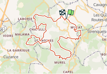

Length
26 km

Max alt
315 m

Uphill gradient
712 m
Km-Effort
35 km

Min alt
136 m

Downhill gradient
725 m
Boucle
Yes
Creation date :
2024-05-30 15:55:59.415
Updated on :
2024-05-31 10:02:40.59
8h01
Difficulty : Very difficult

FREE GPS app for hiking
 SityTrail
IGN / Geographical institutes
SityTrail Plus
The world is yours!
About
Trail Walking of 26 km to be discovered at Occitania, Lot, Le Vignon-en-Quercy. This trail is proposed by Gpoujade.
Description
Boucle balisée au départ de Lasvaux
Positioning
Country:
France
Region :
Occitania
Department/Province :
Lot
Municipality :
Le Vignon-en-Quercy
Location:
Cazillac
Start:(Dec)
Start:(UTM)
389868 ; 4983405 (31T) N.
Comments